 Syken metatietopalvelu
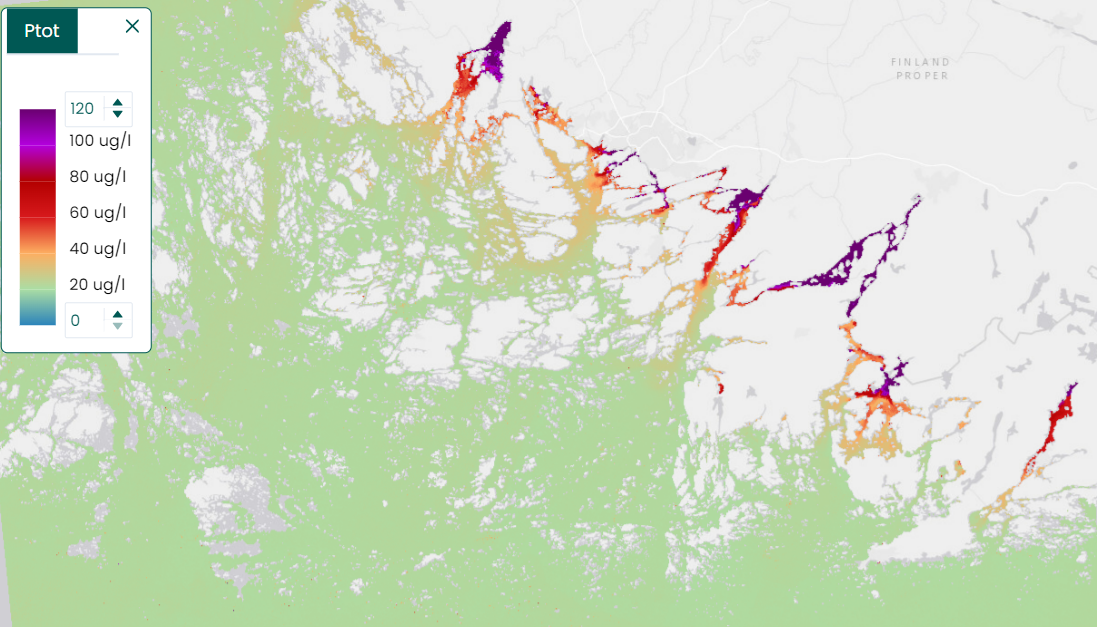
Saaristomeren kokonaisfosforiaineistot (Sentinel-2 & Landsat-8/9) 2018- / Total phosphorus of the Archipelago Sea
[FI] Satelliittihavainnoista havaittu kokonaisfosfori toimii täydentävä tekijänä Suomen rannikkovesien ekologisessa luokittelussa vesipuitedirektiivin (VPD) mukaisesti, erityisesti kun maastomittauksista saatu data on riittämätöntä. Saaristomeren fosforikartat [µg/l] kuvaavat joesta tulevan fosforin määrää. Yhtenäisessä muodossa tulkitut kartat kattavat vuodet 2018–2025 kevään kokonaisfosforin maksimiarvoille (1.5.-31.5.) ja vuodet 2018–2025 kesän kokonaisfosforin keskiarvolle (17.5.-30.9.).
Fosforiaineisto on laskettu päivittäisten sameushavaintojen kevätmaksimista ja kesäajan keskiarvosta. Kevätajan sameushavaintojen maksimi ja kesäajan sameushavaintojen keskiarvo on muunnettu arvioksi kokonaisfosforin määrästä käyttäen Saaristomeren rannikkovesille sovitettua muunnoskerrointa sameuden ja fosforin välillä (yhtälö: Kari Kallio, **Ptot = 1.82*sameus + 20.13**). Sameusarvot on laskettu käyttämällä Sentinel-2 MSI ja Landsat-8 OLI -instrumenttien havaintoja. Satelliittidata on käsitelty sameusarvoiksi käyttämällä C2RCC (Case 2 Regional Coast Colour) -vedenlaatuprosessoria, mutta prosessorin takaisinsirontaa kuvaava lopputulos on muunnettu vastaamaan Suomen rannikkovesien olosuhteita. Kesäajan keskiarvoaineistosta on poistettu sinilevään liittyvät havainnot.
Aineiston maastoerotuskyky on 60 metriä.
Aineisto kuuluu SYKEn avoimiin aineistoihin (CC BY 4.0).
***
[EN] Total phosphorus obtained via Earth Observation serves as a complementary factor in the ecological classification of Finnish coastal water bodies for the Water Framework Directive (WFD), gaining prominence when in-situ measurement data is insufficient. Phosphorus maps of the Archipelago Sea describe the amount of total phosphorus [µg/l] transported from the drainage basin. The maps are interpreted in a unified format to cover the years 2018–2025 for the maximum total phosporus of springtime (from May 1st to May 31st) and years 2018–2025 for the average total phosphorus of summer (from May 17th to September 30th).
The phosphorus data is based on a aggregate of daily turbidity observations. Total phosphorus was calculated by aggregating daily estimates of turbidity derived from satellite observations for the given period (spring and summer). The conversion was performed by using an adapted conversion equation for the coastal waters of the Archipelago Sea, based on the relationship between turbidity and total phosphorus (equation by Kari Kallio, **Ptot = 1.82*turbidity +20.13**). Turbidity values have been calculated by using observations from the Sentinel-2 MSI and Landsat-8 OLI instruments. The processing of the satellite data to turbidity values was done by using the C2RCC (Case 2 Regional Coast Color) water quality processor. The backscattering estimated by the processor has been modified to reflect the conditions of Finnish coastal waters. The observations of the blue-green algae period have been removed from the data.
The spatial resolution of the data is 60 meters.
The dataset follows Syke’s open data policy (CC BY 4.0).
***
WMS-palvelin/ WMS service endpoint: https://geoserver2.ymparisto.fi/geoserver/eo/wms
WMS-taso kevätajan maksimiaineistoille/ WMS layer for the srping time maximum data:
eo:EO_HR_S2_LC8_PTOT_MAX_season
WMS-taso kesän keskiarvoaineistoille/ WMS layer for the summer mean data:
eo:EO_HR_S2_LC8_PTOT_MEAN_season
Simple
Identification info
- Title
-
Saaristomeren kokonaisfosforiaineistot (Sentinel-2 & Landsat-8/9) 2018- / Total phosphorus of the Archipelago Sea
- Date (Publication)
- 2021-09-01
- Point of contact
-
Organisation name Electronic mail address Role Suomen ympäristökeskus / Finnish Enviroment Institute (Syke)
Point of contact
-
SYKE resource classification
-
-
Satelliittihavaintotieto
-
- Keywords
-
-
Ei-Inspire
-
Tarkka
-
status assessment
-
total phosphorus
-
Resource constraints
- Use constraints
- Other restrictions
- Other constraints
-
Creative Commons Nimeä 4.0 Kansainvälinen
***
[FI] Syke on mainittava lähteenä, jos tuotteita käytetään julkaisuissa tai esityksissä tai saatetaan muulla tavoin yleisön saataviin.
Kokonaisfosforiaineistoille: "Syke-aineisto, sisältää muokattua Copernicus ja USGS/NASA Landsat program -dataa (vuosi)".
Lisätietoja: https://wwwi4.ymparisto.fi/i4/fin/eowiki/aineistojen_kayttoluvat.html
***
[EN] Syke must be cited as a source if the products are used in publications or performances or otherwise made available to the public.
For total phosphorus data: "Syke data, contains modified Copernicus and USGS/NASA Landsat program data (year)".
More info: https://wwwi4.ymparisto.fi/i4/eng/eowiki/license_information.html
- Access constraints
- Other restrictions
- Other constraints
- no limitations
- Spatial representation type
- Grid
- Metadata language
- English
- Topic category
-
- Environment
- Oceans
Temporal extent
- Begin
- 2018
Spatial extent information
- West bound
- Infinity
- East bound
- -Infinity
- South bound
- Infinity
- North bound
- -Infinity
- Unique resource identifier
- EPSG:3067
- Codespace
-
EPSG
- Distribution format
-
- GeoTiff ( -)
Digital transfer options
- OnLine resource
- Hierarchy level
- Series
- Statement
-
[FI] Koosteet on laskettu kevät- ja kesäkauden Sentinel-2 ja Landsat-8 -satelliittien sameushavainnoista.
***
[EN] Composites have been calculated from the turbidity observations of the Sentinel-2 and the Landsat-8 satellites for the spring and the summer season.
Metadata
- File identifier
- {72523E9E-7DAB-438E-A63E-011B9484F3FC} XML
- Metadata language
- Finnish
- Character set
- UTF8
- Hierarchy level
- Dataset
- Date stamp
- 2026-11-18T11:50:20.338776Z
- Metadata standard name
-
ISO19115
- Metadata standard version
-
2003/Cor.1:2006
- Metadata author
-
Organisation name Electronic mail address Role Suomen ympäristökeskus / Finnish Enviroment Institute (Syke)
Point of contact
Overviews
Spatial extent

Provided by
